Trail Kinetix · Capabilities
Five disciplines.
One system.
Assessment, design, risk management, planning, and 3D documentation, from people who build and ride trails, not just advise on them.
Trail Condition
Assessment
A systematic site evaluation that tells you exactly what is failing, why it is failing, and what it will cost to ignore.
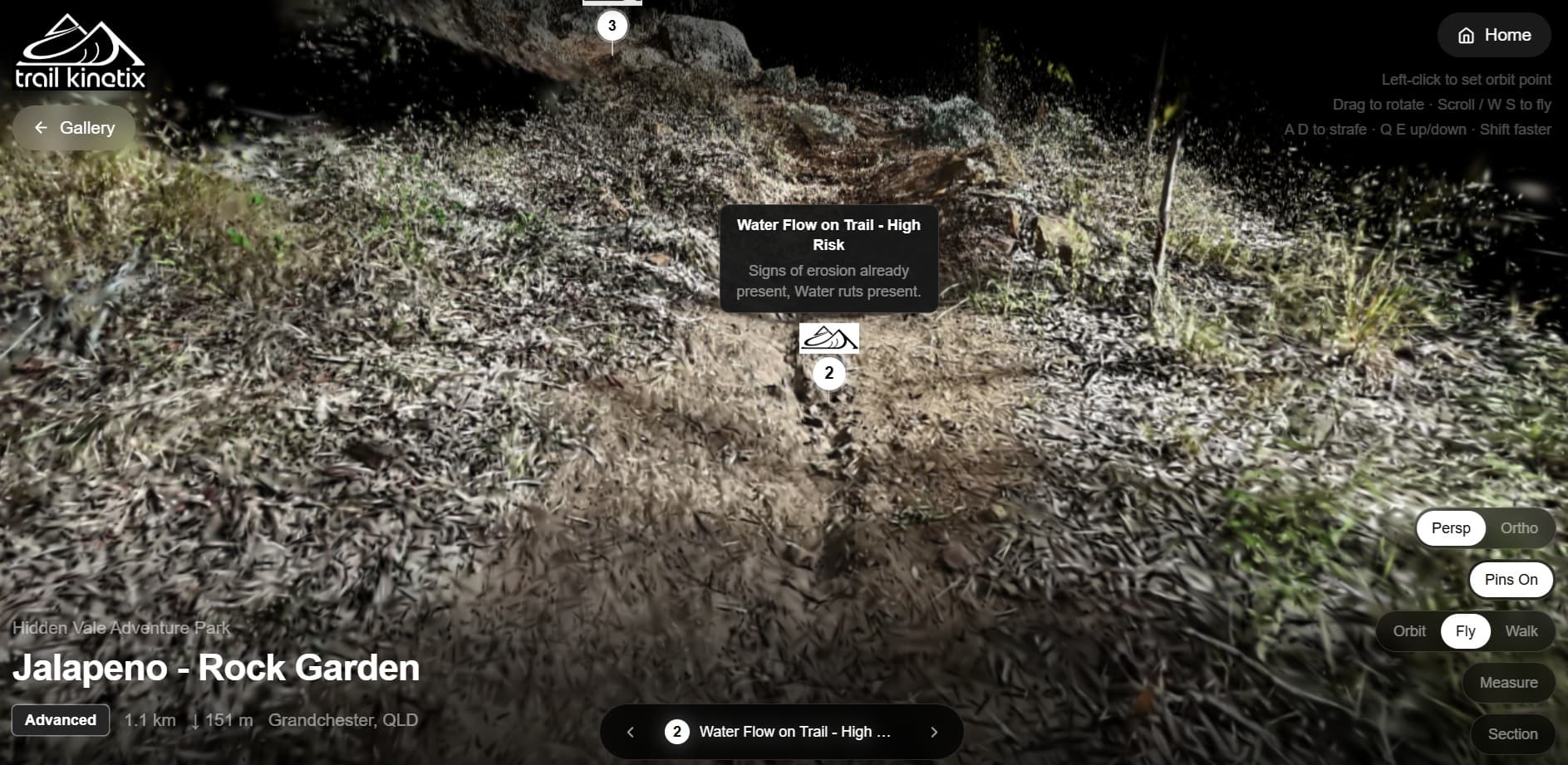
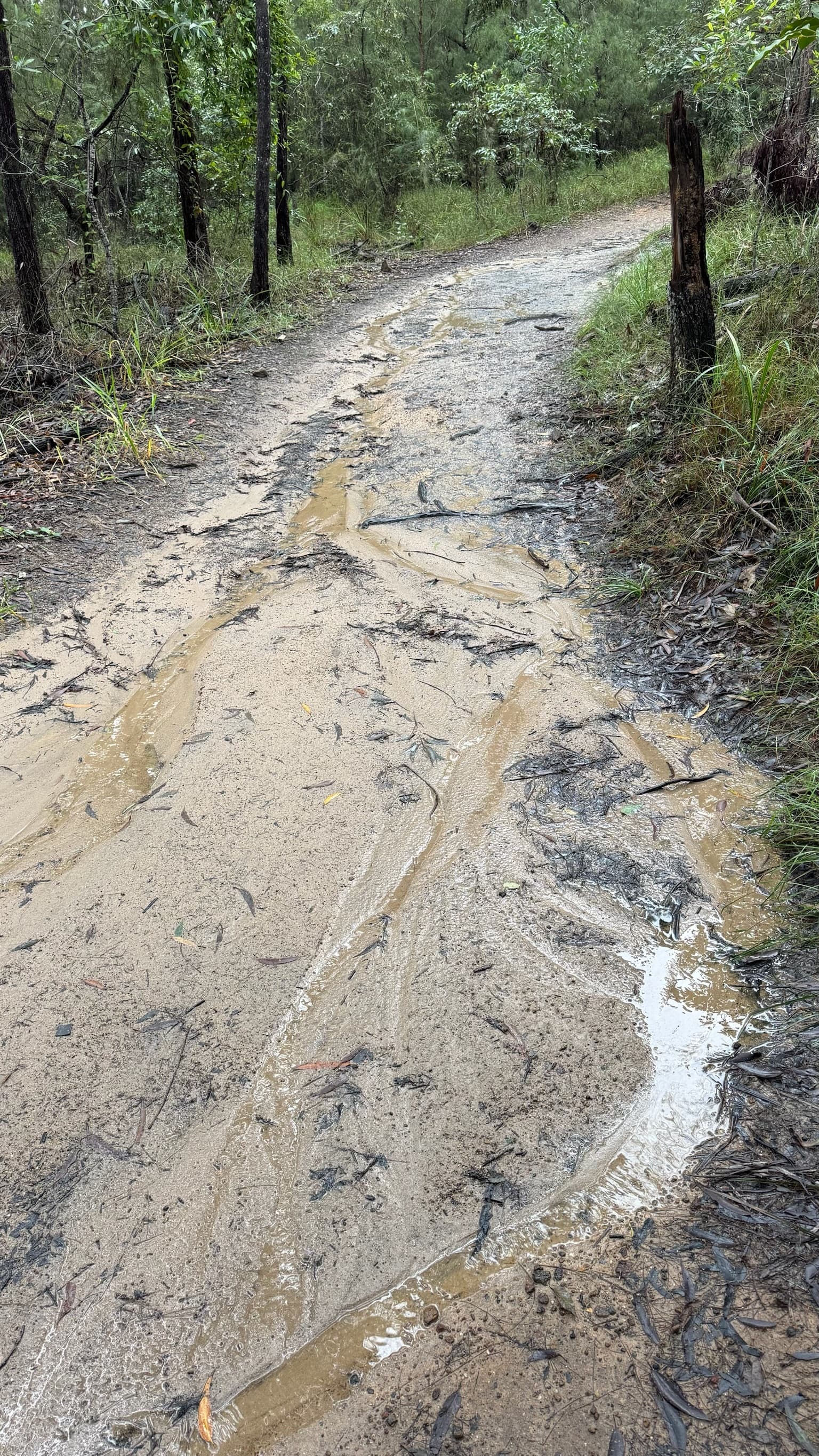
We assess existing trails against drainage behaviour, surface geometry, structural integrity, and feature-level risk. Every finding, maps to a root cause, not a generic checklist. The output is a working document that ranks remediation by urgency and gives your land manager something they can act on.
Where relevant, we integrate our own 3D capture technology to create a permanent, measurable baseline. Each problem is annotated against the actual terrain geometry so there is no ambiguity between our report and the site.
Example Deliverables
Network Planning
& Consultation
Strategy-level work before a dollar is spent on design, feasibility, stakeholder alignment, and network-level thinking.
We work with clubs, councils, and park managers at the point where decisions are still cheap to change. Feasibility analysis, network masterplanning, and community engagement that connects your vision to the land manager approval process.
Where projects require council or government submission, we provide the technical narrative and supporting documentation that moves applications through to approval.
- Flora and fauna impact assessment before any ground is broken
- Corridor routing that avoids sensitive vegetation and wildlife habitat
- Construction-phase environmental monitoring and compliance
- Post-build revegetation planning and long-term site recovery
Trails done well bring people together. We plan networks that give communities a reason to step outside, connecting riders, walkers, families, and first-timers to landscapes they might never have reached on foot. A well-designed trail network becomes infrastructure for community health, local identity, and long-term connection to the natural environment.
Example Deliverables
Trail Design
Geometry that resolves the conflict between rider flow and water flow,before a single cubic metre is moved.
Every TrailKinetix design runs two analyses on the same alignment: where the water goes, and how the rider moves. We resolve the conflict between them on screen, before it gets resolved the expensive way,on the hill, after the first storm and the first season.
Water first. Before a line is drawn, we build a terrain model of the site,from LiDAR or publicly available DEMs where they're good enough, or our own drone survey where they're not. On that model we delineate the catchments feeding every metre of the corridor and run them through our in-house hydrology engine: official rainfall data for the location, time of concentration, and flow volume at any point up or down the slope.
The result isn't a guess about where water will go. It's a figure for how much arrives, how fast, and where,and that's what lets us size the response. Catch drains, crossings, culvert and pipe diameters, grade-reversal spacing: every drainage element is designed to the flow it actually has to carry, not a rule of thumb. Wherever a government rainfall authority publishes design data, we work to it,Australian Rainfall and Runoff, NOAA precipitation-frequency data in the US, or the recognised local equivalent.
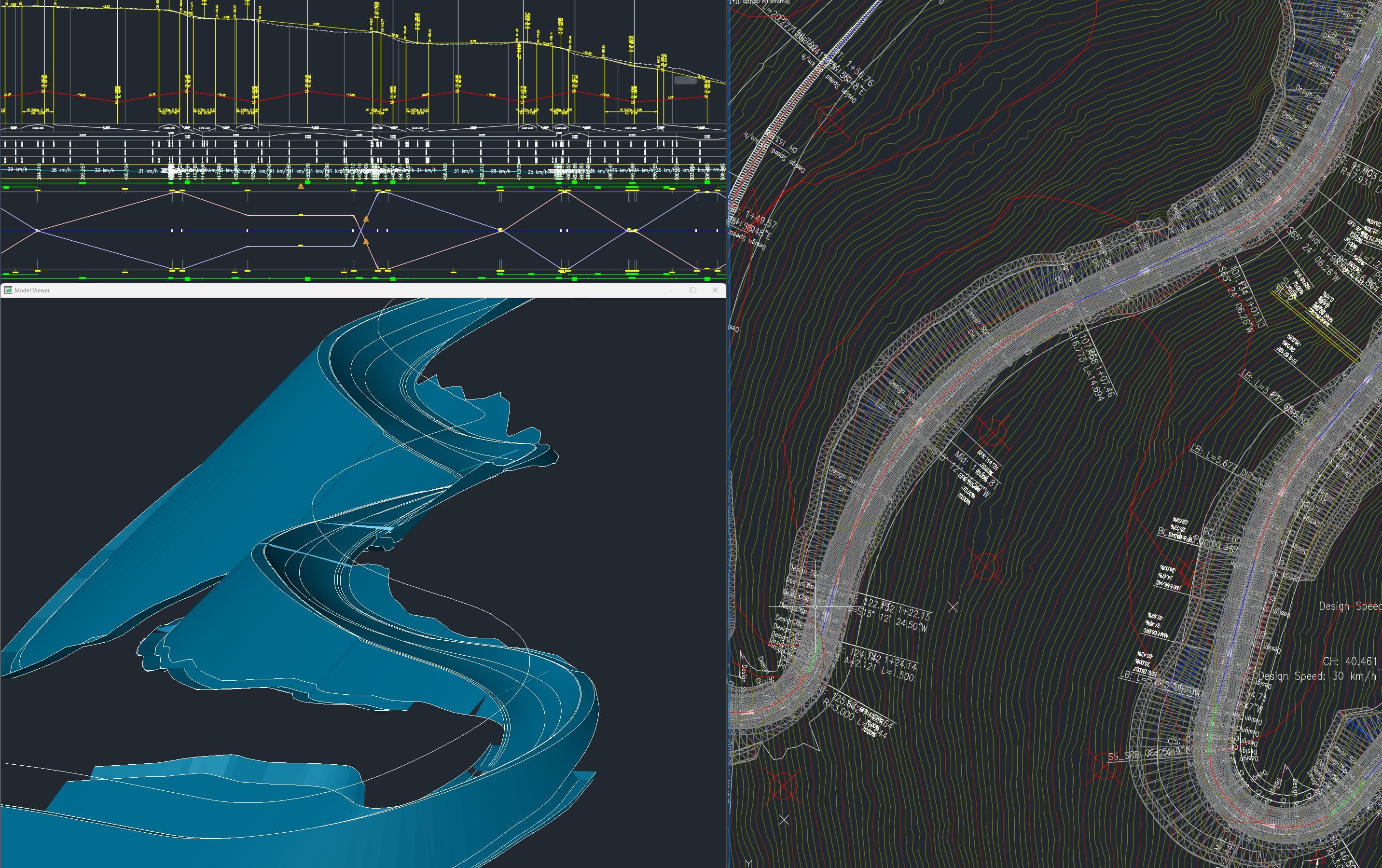
Then the rider. On that same alignment, our in-house geometry engine models the speed a rider actually carries through each section,derived from grade, radius, and the physics of a loaded bike, not estimated by eye. That predicted speed sets the build numbers: feature spacing tuned to the rhythm a rider will be travelling at, berm radius and superelevation matched to the cornering force at that speed, jump take-off angles and heights set to the real approach speed they'll have when they get there.
This is where geometry stops being guesswork. Spiral (Euler) transitions load and unload force the way the body expects it,the difference between a corner that fights you and one that feels inevitable. And when the spacing and transitions are right, something happens that riders feel but rarely name: the trail starts to read as rhythm. The brain's reward system responds to anticipation met by reward,predict the next move, commit, get it right, repeat. A well-sequenced line delivers that loop continuously, the way a beat does in music. Riders don't just ride it. They sync to it. Most builders find that feeling by accident, after enough trial and error. We design for it on purpose.
Every design accounts for:
- Catchment-driven drainage,every drain, crossing and culvert sized to modelled flow, not estimated by eye
- Speed-matched features,spacing, berm radius and superelevation set to the rider's actual predicted speed
- Spiral (Euler) curve geometry,for both horizontal and vertical alignment, so transitions load the body the way it expects
- Sequenced rhythm,feature-to-feature pacing built around the prediction-and-reward loop that turns a line into flow
Deliverables are builder-ready. 3D Trail Model, Alignment drawings, cross-section geometry, drainage logic documentation, GIS output, and a build specification a contractor can pick up and execute without follow-up questions. We understand that design sometimes needs to change due to unexpected finds. We work with this scenario too.
Example Deliverables
3D Trail
Documentation
3D capture of trail corridors, a navigatable, permanent 3D record of your network.
Our capture technology produces photorealistic 3D reconstructions of trail surfaces at detail fine enough to measure surface geometry. Used for:
- Condition monitoring over time
- Insurance and legal documentation
- Stakeholder communication
- Public-facing trail preview
Every trail in our Gallery has been captured this way. The viewer runs in any browser, no app, no headset, no specialist software required.
Example Deliverables
3D Trail Visualisation
Photorealistic 3D reconstruction. Any browser. No specialist software.
Risk Mitigation
& Compliance
Independent assessment that gives land managers, clubs, and insurers the evidence base they need.
Risk on a trail isn't an opinion,it's a set of facts about geometry, speed, sight distance and access that can be documented before someone gets hurt, or after. We assess them independently, so the people carrying the liability have something defensible in front of them rather than a builder's assurance.
Feature-by-feature hazard rating, assessed against the frameworks land managers and insurers recognise. Internationally that starts with the IMBA difficulty model; regionally it's the guidelines built on it,the Australian Mountain Bike Trail Guidelines and Trail Difficulty Rating System, or the equivalent framework for your jurisdiction,alongside the relevant walking and shared-use infrastructure standards (AS 2156 in Australia, or local equivalent) where they apply. Where a duty-of-care or activity standard governs the site, such as the Australian Adventure Activity Standard, the assessment is framed to it.
Every assessment covers:
- Feature hazard rating,each feature rated against the difficulty the trail is signed at, so nothing sits above its grade unannounced
- Sight lines and terrain visibility,approaches, blind crests and run-outs checked against the speed riders actually carry into them
- Access and rescue,machine access for maintenance, and emergency-rescue access along the full corridor
- Signage and closure logic,what to sign, what to gate, and the threshold for closing a feature or line
Applied before opening a new trail. Applied after an incident. Applied when your insurer asks a question you can't yet answer.
We assess against recognised standards and document the result,we don't issue compliance certificates, because in most jurisdictions trail safety is a duty-of-care landscape, not a single certifiable standard. What you receive is a defensible evidence base: feature hazard ratings and a risk register tied to a named framework, that holds up when an insurer, a council, or a coroner asks the question.
Example Deliverables
5
Service disciplines
from one specialist team
3D
Capture technology
proprietary to TrailKinetix
0
Generic reports issued
everything is site-specific